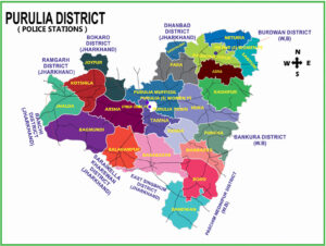
Purulia District lies between 22.60 degree and 23.50 degree North latitude and 85.75 degree and 86.65 degree East longitude. The geographical area of the district is 6259 sq. kms. The natural forests of the district are mostly of mixed nature and restricted to Northwest part of the district covering Ajodhya Hills and Panchet Hills of Northeast. The approximate area covered by forest is 1857.26 Sq. KM i.e. about 29.69 % of the total land area. This district is encircled by Bankura, Midnapore and Burdwan district of West Bengal and East Singbhum, Saraikela-Kharswan, Ramgarh, Ranchi, Bokaro & Dhanbad of Jharkhand state.
As per 2011 census, total population of the district is 2930115, Average literacy rate of Purulia in 2011 were 64.48 compared to 55.57 of 2001. If things are looked out at gender wise, male and female literacy were 77.86 and 50.52 respectively. For 2001 census, same figures stood at 73.72 and 36.50 in Purulia District. Total literate in Purulia District were 1,624,905 of which male and female were 1,002,058 and 622,847 respectively. In 2001, Purulia District had 1,182,284 in its district.

 Skip to content